Home | Summary | Demos | Workshop | Reports | Links |
OverviewThe costs to industry of inaccurate wind and wave information are high. Recent studies of insurance data indicated weather related losses of 2.5 billion Euro per annum. In a single incident a container transport experienced damage to the value of 100 million Euro. Operators are clear that they require better provision of sea state data than is presently available. The aims of the COMKISS programme were twofold: To demonstrate to major segments of the marine industry the benefits that of satellite-derived information on sea surface winds and waves, and to test the potential added value of satellite data in new applications. Three main offshore industry sectors were selected: ship design and certification the transportation of very large loads such as dock cranes and offshore platforms, and the operation of high speed craft. What these segments have in common is the little use they have made of satellite data in the past. Where historical information on sea state has been required to evaluate ship or platform performance, then meteorological hindcasting was (and is) the favoured source. It is only very recently that an independent assessment made within the industry itself has concluded that statistics derived from satellite observations appear the more reliable. Other commercial concerns are now more prepared to test their current method of operation against the satellite record and this is what is attempted in this project. The PartnershipThere were six partners in the COMKISS programme, with a strong end-user representation covering three sectors of the offshore marine industry. The two industrial partners, Dockwise and Bureau Veritas, guided the investigations in their areas of interest and adjudicated the results. A further unfunded partner, Corsica Ferries, co-operated on a voluntary basis allowing an analysis of High Speed Craft operations. There were four scientific partners: IFREMER, a large marine research organisation; The University of Lünd, a university department specialising in the statistics of waves; Optimer, an engineering Metocean studies company; and Satellite Observing Systems, a leading EO value-added company specialising in providing satellite-derived marine information. Partner’s responsibilities within the COMKISS project are given below:
Rationale, Objectives and Time ScaleWithin the general objective of demonstrating marine applications of satellite data to the offshore industry were 8 individual studies — aimed at testing the potential benefit, in terms of improvements to safety and economy, of specific applications of satellite data. These applications fell into two general categories: provision of Near Real Time data to operational offshore activities, and application of climatological databases for planning and design. It might be expected that almost twelve years of continuous sea surface measurements from a succession of spacecraft would provide the reliable statistical record of conditions that is required for design planning. However, it is much less obvious that the few satellites currently operating can provide real-time updates on sea-state frequently enough throughout the day to assist in routine operations. COMKISS investigated the minimum requirements of the marine operations; for it should be possible, if there were sufficient interest, to introduce a ‘fast-delivery’ mode on all wave measuring satellites operating now and in the future. COMKISS began in August 1998 with the first application studies, analysing immediately available databases. Preparation of further databases continued to summer 1999, followed by trials of real time data. Analysis of databases, and development of statistical techniques, continued to spring 2000. Towards the end of the project, in spring/summer 2000, the end-users assessed the results of the COMKISS studies. These assessments were used to create a series of web based Demonstration Modules, available at http://www.ifremer.fr/metocean/shipping.htm. In the final phase, the various findings were combined into recommendations for further work and to achieve greater exploitation of satellite data. The project closed in October 2000 at a COMKISS workshop, held as part of the International Association of Oil and Gas Producers (OGP) MetOcean Committee’s Joint Industry Programme Week. At this meeting COMKISS results were presented to influential representatives of the offshore end-user community. Highlights and Achievements
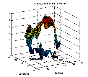
The exact nature of the geographical and temporal distributions of sea state parameters is important when calculating the long term consequences of fatigue on a given route, or the possible propagation of critical structural weaknesses which may lead to failure under severe conditions. Techniques were developed to generate continuous, detailed, and route specific statistical databases from satellite data. These types of data bases are essential to enable more reliable calculations of important vessel response characteristics (see Figure 1).
Figure 1. The 10% significant wave height (Hs) quantile for the Rotterdam to Trieste shipping route. The route starts at Rotterdam at the right hand side (52°N, 4.5°W), and finishes almost directly below, south of Trieste (at 45.5°N ~10°E) The section in the Bay of Biscay (Brest to Gibraltar) is clearly the roughest. The vertical scale and colour give Hs in m.
Present techniques for calculating the response of vessels to sea conditions often make general assumptions about the statistical nature of the response distributions. These techniques play an important role in establishing design criteria for vessels. An important achievement of COMKISS was the development, using satellite data, of a more robust theoretical basis for such work.
Oceanographers have developed techniques to extract ocean surface current information from satellite measurements. Apart from a few specialist regional applications, these techniques have not yet been fully developed for commercial exploitation. Within COMKISS we investigated whether these satellite data could be exploited in more widespread applications to improve route selection and shorten voyage duration. It was shown that further work was necessary, but that the use of satellite data could help to reduce costs for end-users through reduction in, and improved predictability of, travel times.
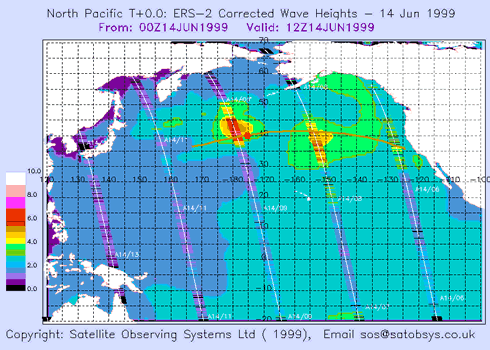
Within COMKISS, Satellite Observing Systems developed and trialed the "Sea State Alarm Service" in which real-time satellite data were transmitted direct to offshore marine operations. Dockwise participated in the trial on a cable laying operation across the North Pacific, and the ship’s officers reported increased confidence in assessing sea state conditions. (see Figure 2). Strong interest from specialist offshore operators indicate that a commercial application may be feasible, and future developments are planned.
Figure 2. An example of data from the new "Sea State Alarm Service" tested within COMKISS.
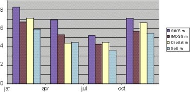
Wind and wave climate data bases are used for the design of ocean transport vessels and for pre-operational planning. It is perhaps surprising that many offshore operators still choose to use metocean climatologies based on visual observations. Using a software tool developed for the OGP, COMKISS compared climatologies derived from visual ship based observations, hindcast wind/wave models, and from satellite data (see Figure 3). Whilst the range of wave parameters available from satellite data is still limited, the satellite databases were shown to be consistent with the best of the alternative climatologies.
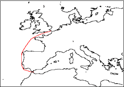
Figure 3. A comparison of 3 data bases over the Dover to Gibraltar Route, giving voyage Hs over four seasons. Cliosat and SOS are satellite data bases, IMDSS is a hindcast data base, GWS is derived from visual observations. These results demonstrate a clear inconsistency between the GWS and the other three.
Corsica Ferries operates between Italy, France and Corsica. On several occasions during each summer season they find that some sailings, cancelled because of forecasts of severe weather conditions, actually could have taken place. On other occasions ferries already en route have been forced to turn back because they encounter bad weather that was not forecast. Each time the ferry company faces extra costs and passenger dissatisfaction. Accurate real time data could help to reduce the number of these events. COMKISS demonstrated that the present satellite provision of wave data was not sufficient and that higher frequency data coverage was required. End User Evaluation - COMKISS WorkshopThe evaluation of end-users was of central importance to COMKISS. COMKISS consulted the wider offshore community through the COMKISS/OGP workshop. To allow this workshop to take place within the COMKISS project time scale, the team requested, and was granted, a two month extension. General end user comments are summarised below: End User Comments
COMKISS ConclusionsCOMKISS has demonstrated to segments of the offshore industry the benefit of marine satellite data in a range of operational applications. In some limited areas, the market is already well supplied with high quality products, in others there are fundamental limits in the ability of satellites to provide the required information. Generally speaking, improvements can be achieved in two ways.
It seems likely that modifications to models can only achieve limited improvements. If models go to higher resolution, then they require reliable high resolution input. This in turn will be best provided by satellites. However, the initiation of new satellite missions requires significant initial investment that the offshore industry is not prepared to provide. For instance a constellation of 5 GANDER wave measuring micro satellites would cost roughly 50 million Euro, a new (mini) satellite to provide global directional wave spectra (SWIMSAT) is estimated to cost about 100 million Euro. If these new satellites are to be launched, public money must be invested and so a public interest case must be made. Suggested Further WorkSuggestions for further work were developed following end-user comments. Climatological Applications
Near Real Time Applications
ExploitationLimited improvement to data provision is expected in the short term. During 2001 two new satellites operating altimeters will be launched (JASON and ENVISAT). ENVISAT will also carry a Synthetic Aperture Radar which will operate an ocean wave measuring mode. Both satellites will have near real time data capability and it is intended to carry out further trials of the Sea State Alarm service, and to develop new assimilation techniques which will provide better consistency between measured data and model predictions. Project planning is already under way for these activities, in the latter case through a proposal, named COMKIAS, for which EUREKA status is being sought. COMKIAS will also develop and test an on-board advisory system which merges external met ocean predictions with on-board ship measurements. A technical feasibility study for the GANDER project has demonstrated that a constellation of low cost micro-satellites could hosts wave measuring altimeters and so provide higher spatial and temporal coverage at a fraction of the cost of the large scientific missions (ENVISAT, JASON). The GAMBLE proposal, currently under evaluation at the EC, plans a network to make maximum advantage of the combination of such a constellation with the scientific satellites JASON and ENVISAT. Direct exploitation of the COMKIAS project will take the form of distribution of copies of the Final Report and a CD with all project documentation. Presentations will be made at appropriate industry forums The COMKISS web site at http://www.maths.lth.se/matstat/staff/georg/comkiss/ will be maintained and feedback noted. ContactFor further information, or for copies of reports or a CD containing pdf and html report and demonstrations, contact Satellite Observing Systems Phone +44 1483 421213 |