|
Satellite Observing Systems (SOS) offers unrivalled
expertise in all aspects of satellite remote sensing of the marine
environment. The company serves public and private sector organisations
by providing:
- Consultancy on the applications and exploitation of
marine remote sensing (see Projects),
- High quality marine statistics and climatology (see Services
and Data
),
- Real-time sea-state monitoring from space delivered
to international users (see Services and
Data),
- Training programmes world-wide (see Publications).
Some of the problem areas recently tackled by SOS,
including ongoing programmes, are:
- Calibration of radar altimeters on the ERS-1, ERS-2
and ENVISAT satellites,
- Statistical data on the occurrence of the highest
wave at an offshore site or along a shipping route anywhere in the
world,
- The prevalence of oil slicks in summer off a tourist
beach in the mediterranean,
- Seasonal cycles in the vertical migration of
nutrients along a coastline, and their dependence on marine weather
patterns,
- A model of sea level changes around Britain's
coastline over the last decade,
- The design of an easy-access coastal information
system containing data derived from the satellite record,
- Accessibility of environmental information of coastal
zones by NATO navies,
- Trends in global climate change revealed in the
middle of the Atlantic by satellite observations repeated over a decade.
SOS has longer experience in the field of creating
useful marine products from raw satellite data than any company in
Europe, and this is reflected in the number of Training Workshops it
has been asked to organise around the world.
- We invite any organisation, country or agency wishing
to understand more about the value of satellite marine products to make
contact
with SOS.
- We are completely current with the programmes and
aspirations of all the major space agencies and we are a leading
promoter of 'real-time' constellations.
- No organisation, whose interest lies in the sea, can
afford to remain ignorant of the increasingly relevant role of
satellite surveillance to its operations.
|
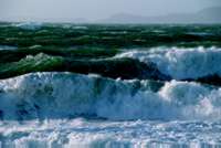
Several satellites measure the
height of waves at the sea surface. SOS archive these and windspeed
measurements in the WAVSAT database. This
then used to provide high quality marine statistics and climatology.
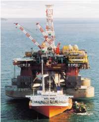
Transporting a 33000 ton
semi-submersible safely from Canada to Brazil depends critically on
making the best use of whatever information is available on sea-state.
SOS worked closely with Dockwise on the COMKISS project.
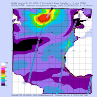
The SOS Sea State Alarm service
(see Services)
transmits reports to ships comparing actual sea state along the
satellite tracks with the forecast.
|
