 |
|
 Overview
Clean Seas was a three year investigation, part funded
by the European Commission, to investigate marine pollution monitoring using
satellite borne instruments. The mission statement was: 'To evaluate the overall
contribution that Earth Observation data can make to the routine surveillence
of pollution in the marine environment and in so doing, establish the means
by which observations of oceanographic features and possible pollutants may
be integrated to create a single information source from the disparate satellite
data streams currently available'.
Clean Seas co-ordinated the work of a number of major European research centres in France, Germany, Italy, Spain, Sweden and the UK in a programme designed to evaluate the contribution that present and future satellite surveillance systems can make to the monitoring of marine pollution. The approach was to make systematic measurements over 3 coastal zones - one in the Mediterranean, one in the southern North Sea and one in the Baltic. Previous experience has shown that oil slicks, effluent discharges and algal blooms can be detected by satellite-borne synthetic aperture radar, by infra-red and by colour sensors. The objective of this programme was to quantify the effectiveness of these sensors, acting singly or in concert, by repeating the observations at least every 35 days (the repeat pattern of ERS 1 & 2) over a period of 2 years. Every effort was made to gather all relevant meteorological and oceanographic data over the selected sites so that a much greater understanding of the conditions under which surface features can be imaged was be built up. The project grew out of the need identified on 6th October 1994 at the 6th meeting of the Committee of Ministers of the Council of Europe to demonstrate the use of space technology in 4 major hazard areas. These are: forest fires floods earthquakes marine pollution.
Over the three test sites of the Clean Seas project, several thousand images were collected by space borne instruments, measuring colour, temperature and surface roughness over large areas of sea around EuropeÕs coast. These raw data were examined, and the features identified in each image were published on a dedicated world wide web site to allow the project partners fast and easy access to the information needed to tackle the project objectives. These were:
|
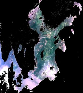
The colour of the sea varies according to its composition and the way in which it is illuminated. Sediment suspended in the water column by recent release from a river or resuspension through the action of tides and currents can be detected. Perhaps of greater significance, however, may be the biological content of the water column such as this image of an algal bloom in the Baltic sea.
Chlorophyl, used by microsopic marine organisms for photosynthesis, subtly changes the colour of the water, and by measuring the relative strengths of different colours seen from space, accurate estimates of the concentration of chlorophyll can be made. |
|
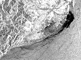
Pollutants released at one point are carried by tide and current and, because of small differences in the temperature of the sea surface, the bodies of water that carry the pollutants can be mapped and their progress monitored using precise temperature measurements. Temperature images provide valuable inputs to hydrodynamic models which are necessary to predict where pollutants are likely to end up, whether on a tourist beach, a commercial fishery or other environmentally sensitive site. The models are particularly important when the pollutants are not visible directly from space, for example heavy metals from riverside industries detected at the river mouth before release into the sea.
In addition to spotting possible pollution incidents at sea, models developed during Clean Seas predict the transport of pollution at the surface - for examplein the case of bilge water pumped into the sea illegally and carried by surface winds and underlying currents to impact on the coastline.
|
|
 |
|
The Sythetic Aperture Radar (SAR) is a complex instrument which measures the roughness of te sea surface - roughness caused by the wind blowing over the sea; a roughness which can be damped by the presence of oil and other 'surfactants'. SAR can be used in near real time to try and catch and prosecute ships dumping oil at sea or, perhaps more usefully, it can act as a planning and long term monitoring tool to enhance the effectiveness of sea level and airborne monitoring campaign which are better able to gather the physical evidence needed for prosecution. |
|
 |
Focusing on a few promising Earth observation
topics, the Clean Seas project produced original results in a number of areas:
Multi-sensor analyses: Within a 2-hour period on the morning of 15 July 1997 images were acquired over an extensive algal bloom just south of the island of lund in the Baltic Sea. For the first time, colour, temperature and SAR observations of the same bloom were available, allowing aspects of the bio-chemistry and imaging physics to be examined in detail.
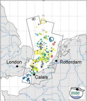
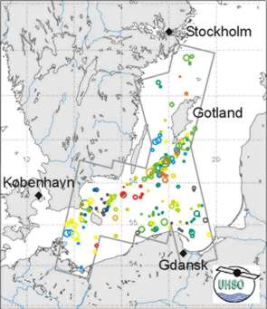
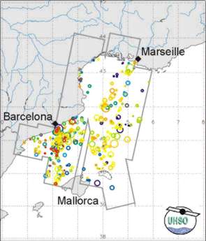
Spill Statistics: Slicks of mineral oil can be identified in many of the 780 SAR scenes acquired by the project - all in European Coastal seaways where such discharges are illegal. Analyses of the detection rates and the distribution in space and time of the slicks identified by the project are producing advice on the most cost-effective way of using this expensive technique as well as allowing conventional resources to be targeted more effectively.
Dynamic mapping and prediction: Pollution in the marine environment rarely stays in the same place; it is carried by tides and currents which may disperse or contain it. Maps of fronts and eddies detected in all three classes of sensor (in particular by the temperature instruments) are providing valuable inputs to the development of robust and reliable prediction tools which allow the behaviour of some unwanted sea water constituents to be modelled.
Dispersion: Water can flow smoothly, allowing pollutants to disperse slowly though evaporation or settlement or the flow can be chaotic and turbulent in which case dispersion can be accelerated (or in some cases, constrained). Classification of turbulence signatures is allowing areas to be identified where these different behaviours can be found in order that modelling of surface transport be improved.
River Plumes: The behaviour of river borne pollution such as pesticides, heavy metals and anthropogenic compounds must be described accurately if the full significance of in-situ monitoring campaigns is to be realised. Clean Seas has improved the understanding of the dynamics of the Rhine river plume and its interaction with the tides and currents which may carry pollutants as far as Denmark and Sweden.