 |
Case study: HSC performance
|
|
|
 |
The behaviour of High Speed Crafts (HSC) in rough seas depends on two main points: detailed characterization of sea states and accurate response modelling to sea conditions.
A main objective of the studies of HSC performance is to improve the structural safety of HSC's, by the use of a refined characterization of sea states to predict responses and stresses.
Another major objective is to control ship behaviour with respect to passenger comfort.
In situ measurements are available only at few locations and therefore cannot be generalized.
The main other sources for sea state characterization are hindcast models and satellite observations.
The contribution of the latter is assessed in the present study.
|
 |
 |
General description
|
As for conventional ships, the main HSC response parameters that have to be considered for the study of their behaviour at sea can be summarized as follows:
|
Accelerations
in the 6 degrees of freedom (heave, pith, roll, sway, surge,
yaw), that are of main importance for passenger comfort. Because
of HSC's particular behaviour at sea, compared to conventional
ships, these parameters have to be analysed very carefully. |
|
Ship
motions in the same 6 degrees of freedom, which are particularly
important for ship maneuvrability. |
|
Strains
in all structural parts, that are of prime importance to ensure
structural strength. |
These
parameters are studied and calculated by Naval Architects and Engineers,
on the basis of specified local sea conditions in the area of operation,
and in relation with the specified HSC performance (operational
speed, etc.) These studies also lead to the analysis of operational
limits, with respect to passenger comfort or ship behaviour, resulting
into limits of operability, specified as limits of significant wave
height for safe sailing.
For these studies, the following metocean information is requested:
|
directional
wave spectra over the whole area, |
|
wind
speed and direction over the whole area, |
|
current
speed and direction over the whole area, |
|
tide,
when relevant. |
Among these parameters, the main ones are those related to wave conditions, because they are of prime importance with respect to accelerations, motions and strains.
But there is often few information available on directional wave spectra and only statistics of a few wave parameters can be made available:
significant wave height, associated wave period, associated wave direction; whereas other wave characteristics are also of importance to refine engineering studies: wave shape and spectral bandwidth, directional spreading, and crossed seas indicators.
|
|
|
Typical applications
|
Typical applications cover not only the performance of high speed crafts, but also the planning and the safety control of operations at sea, especially in coastal areas, and of other marine logistics, as well for industry as for fishing, or for tourism for instance.
|
|
State of the Art - Old and new
|
 |
|
Present methodology
|
Observations fall into three categories:
observations from land stations,
ship observations,
and site measurements, on land and coastal stations or from buoys.
Land and ship observations are very useful, for maritime operation management, because they are dispatched very rapidly.
They are used routinely by HSC operators for decision making.
However, the accuracy of visual observations is rather poor, in general, for the purpose of climatological statistics.
Therefore, the observations used for climatological studies are often limited to wind measurements from land stations and to wave measurements from wave buoys. There are also some coastal stations with wind and sea measurements (and other air and sea parameters in general).
When available, such local measurements are of prime importance.
Even if they do not represent the climatology of a large maritime area, but a local climatology only, and even if the duration of site measurements is often limited to a few years, they are the most reliable information in general.
Hindcast data is an alternative source of data (or a complementary one), because hindcast models can produce long time series of wind and sea parameters, over large areas. However, wave fields may not be easy and cheap to get access to.
Beside the availability of hindcast data from suppliers, there are also some limitations in the use of hindcast data for HSC performance studies.
For instance, the wind fields over Nice-Corsica area from ECMWF have a grid size of 1.125� x 1.125� and a time step of 6 hours, what is not too coarse to represent spatial variations and rapid changes of wind and sea conditions in the area.
In addition, hindcast models have also some limitations, particularly when used in semi-enclosed or in enclosed seas, because the physics involved in the phenomena are very complex.
|
 |
|
Case study
|
The present study focussed on the specific case of Nice-Corsica route, that is operated with HSC's during the summer season by Corsica Ferries.
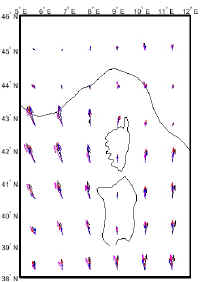
There are at least three different areas along that route, one close to Nice with land influence, another in open sea (area known as Balagne) and a third one near Cap Corse , with specific sea conditions related to the local orography.
Detailed analysis of sea conditions along Nice-Corsica route, as well as other HSC routes, would request large efforts as well as detailed wind and wave data that are generally not available.
Consequently, at present time, only global sea conditions can be made available, either from satellite observations, or, as mentionned above, from hindcast models and site observations.
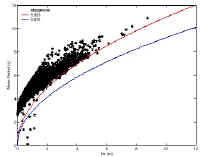
Significant wave height, wind speed and an estimate of wave period climatologies can be derived from altimeter data.
Other parameters (directional and spectral) have to be acquired from other sources, either from other satellite instruments such as wind scatterometer and Synthetic Aperture Radar in wave mode, or from conventional sources.
For Nice-Corsica routes, only altimeter data were available.
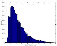
For the present study, the TOPEX and POSEIDON altimeter significant wave height (Hs) wind speed (U10) data, together with an estimate of mean wave period (Tm) have been extracted from archived GDR data.
Data, covering the period October 1992 to December 1998, from tracks 009, 085, 161, 044 and 222 have been extracted within the region 40�-45�N and 6�-12�E.
A main advantage of satellite data is that they cover long durations (over nearly 10 years at present time) which is of evident interest from a statistical point of view, considering the interannual variability of wind and sea conditions.
However, it must be considered that because satellite coverage is too scarce, peak storm conditions are often not observed and, therefore, wind and sea statistics may be biased for severe conditions.
In addition, it should be made clear that statistics of altimeter data are prepared generally for large maritime areas with somewhat varying local climate, as discussed above for Nice-Corsica area.
In particular, wave conditions are significantly different in open seas and in coastal areas, and in addition, there is evidence that the altimeter may under estimate wind speed (by up to 30%) in semi-enclosed and enclosed seas.
|
 |
|
Analysis of the example
|
When climatological statistics are available over an operational area, or over several maritime areas, if necessary, depending on the variability of wind and sea conditions over the routes, then a precise analysis of HSC performance can be carried out.
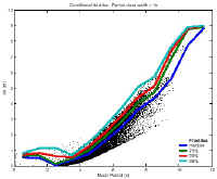
The basic idea is to build transfer functions to represent HSC response, in terms of acceleration, motion and strain, as discussed above, in relation with directional wave spectra and with HSC speed and relative heading.
If directional wave spectra are not available such transfer functions can still be built however, from Hs and Tp, with some assumptions on wave spectra and on directional wave spreading.
Then, the HSC performance can be analysed, on a monthly basis if necessary, in relation with operational limits on acceleration, motion or strain.
For instance, this can result in estimates of stand-by duration for bad weather conditions, on a monthly basis.
The main advantage of such an approach is that it leads to quantified performances of any HSC.
In particular, such analyses can allow drawing conclusions on HSC performance in various maritime areas, with respect to their different climatologies.
The statistics that could be estimated from satellite data meet most of the above requirements when they are supplemented with wind hindcast data.
From this analysis, it results that use of standard hindcast data and satellite observations, validated with site measurements when available, allow for development of adequate climatological statistics for HSC performance analyses.
There are however some limitations that could be cleared with refined hindcast models, with more satellite observations and with more site measurements.
|
|
|
|
|
Research actions
|
| The analysis showed some limitations in the resolution of hindcast in this area of the Mediterranean Sea, where local conditions can influence weather and sea states, with sometimes rapid changes from mild to severe weather conditions.
Fine resolution affordable hindcast models would be needed, in relation with rapid and local changes of weather conditions in the Mediterranean Sea, to supplement satellite data. |
| Satellite coverage is too scarce, and has measurements limited to narrow tracks in general.
Sensors that could provide spectral directional information are also not operating sufficiently often in the Mediterranean.
|
|
|
|
User persuasion
|
| HSC operators are motivated, and would be easily convinced if climate information were complete, detailed, and available at affordable costs. |
|
|
|
Expected improvements
|
| It would be necessary to improve by an order of magnitude the time and space coverage of altimetric sensors, which could be done if a large number of satellites were launched. |
| Directional spectral information is further needed to validate and supplement hindcast. |
|
|
Links and references
|
|
|
Providers of Climatologies
|
|
|
|
The COMKISS project:
|
 Project objectives
The main objectives of the project are:
to demonstrate to major segments of the marine transport industry the
benefits of integrating satellite-derived information on sea state such as
wave height and direction.
to raise awareness of the usefulness of satellite data in increasing the
safety and overall efficiency of shipping operations by using the EWSE
(at CEO) as the principal channel for communicating progress.
The results should be of interest for enterprises such as ship certification, fast
ship/coastal traffic, and transportation of unconventional loads.
Project partners
Satellite Observing Systems , Godalming, UK
(David Cotton, project manager)
Mathematical
Statistics, Lund University, Sweden (Georg
Lindgren, project
co-ordinator)
Bureau
Veritas, Paris-La Defense, France (Guy
Parmentier)
Dockwise, Meer, Belgium (Cees Leenaars)
IFREMER, Brest, France
(Michel Olagnon)
OPTIMER, Brest, France (Raymond Nerzic),
Corsica Ferries, Bastia, France
Project period
September 1, 1998 - August 31, 2000
|
Back to top | Back
to modules list
|