 |
Case study: HSC operation
|
|
|
 |
A main problem in the management of High Speed Crafts (HSC) is their vulnerability to rough seas.
For instance, HSC's operated by Corsica Ferries are able to sail in comfortable conditions for passengers up to sea states with significant heights less than 4 meters.
This limit was set up in accordance with regulations from Certification Authorities and confirmed by Corsica Ferries experience.
Hence, the operational problem is to know accurately what will be the severity of the sea states encountered during future crossings with enough anticipation.
For commercial reasons, the Ferry Company must be able to inform all their passengers with enough advance notice that the crossing will not be possible by HSC because of weather conditions. When this is the case, conventional ferries ensure crossings.
If the marine weather forecasts underestimate the sea conditions, and if very rough seas are encountered, the ship will sail slowly, the travel will not be comfortable and the passengers will be dissatisfied, with some unwanted commercial consequences.
On the contrary, if the weather forecast overestimates the conditions, the Ferry Company will cancel the HSC crossing while it would have been possible; with unfavourable commercial consequences.
The purpose of the present study is to investigate whether improvement of weather forecasts could result from a better utilisation of satellite observations on a near real time basis.
|

|
 |
General description
|
Fortunately, problems occur only in a limited number of cases.
As an example, on the routes operated by Corsica Ferries with HSC's between Nice (France) and Bastia or Calvi (Corsica) and also between Savona (Italy) and Bastia,
during the 1999 summer season of Corsica Ferries, sea conditions were quite severe on half-a-dozen occasions:
|
on
July 22 & 23, with winds up to Beaufort 8 and waves up to
3.5m, |
|
between
August 11 & 17, with winds up to Beaufort 8 and waves up to
3.5 or 4m, that is the HSC operational limit, |
|
on
September 3, with winds up to Beaufort 6/7 and waves up to
3m, from weather forecast (there were no observations), |
|
on
September 15, with winds up to Beaufort 7/8 and waves up to
3m according to weather forecast, but only Beaufort 6 and
2m waves from observations, |
|
on
September 20, with winds about Beaufort 6 and 2.5 m waves
according to weather forecast, but Beaufort 7 and 3m waves
from observations. |
The purpose of this study
is to try to find ways to reduce discrepancies between the forecasts
and the actual conditions by a better use of satellite data.
|
|
|
Typical applications
|
Typical applications cover not only the operation of high speed crafts, but also the planning and the control of operations at sea, and of other marine logistics, as well for industry as, for instance, for fishing or for tourism.
|
|
State of the Art - Old and new
|

|
|
Present methodology
|
Met-Offices provide the ferry companies with weather forecast reports.
Forecast data are derived from an analysis of meteorological conditions collected by the forecaster and from the application of forecast / hindcast models.
The meteorological conditions are collected most of the time from the ECMWF model and from meteorological stations along coast in the region of interest, and when available, from marine weather buoys.
Often, the data issued from the models are analysed further by meteorologists from a local service before they are dispatched to the ferry company.
In addition to weather forecast bulletins, ferry companies also use information from other available sources such as observations from coastal land stations, observations from other ships sailing in the area and site measurements (from wave buoys for instance) when they are available.
There is a clear demand from HSC operators for more information on weather conditions, particularly when sea conditions are changing rapidly.
Obviously, the demand is for reliable information (i.e. for more site measurements) and for reliable forecasts, on a near real time basis.
|
Case study
|
Satellite measurements of sea state and wind over the Corsica Ferries routes, during their operating season, were used to assess sea conditions on selected occasions.
Unfortunately the coverage of ERS-2 scatterometer (measuring wind fields) and SAR wave mode data (providing images of sea states) is poor in the Mediterranean, and no data were available in the Corsica region for summer 1999.
This poor coverage follows partly from the fact that the ERS-2 SAR is often switched to image mode over the Mediterranean, which then means that neither scatterometer nor SAR wave mode data are available, and partly from the numerous islands in the Mediterranean which mean that even when the scatterometer is switched on, valid ocean returns are rarely received on all three of the scatterometer antennas.
In the latter case further off-line processing is necessary to retrieve valid wind data, and although a scheme has been developed, these data are not available for 1999.
Thus, only altimeter data have been extracted.
Satellite Observing Systems have extracted wind speed and significant wave height data from ERS-2 and TOPEX, for the months of May to September, for all data within 40�-45�N, 6�-12�E (note that TOPEX-POSEIDON satellite was fitted with a second altimeter, known as POSEIDON, from which only few altimetric measurements were recovered).
Both data sets are retrieved from the fast delivery data streams, and so have not undergone any post processing by the designated processing facilities.
This can mean that certain aspects of quality control are not carried out and some doubtful data may remain in the data stream.
Wave period estimates are calculated from the algorithm developed by Davies et al. (1998).
The main weather forecast data used by Corsica Ferries for their applications were made available to the COMKISS project, with the sea conditions observed on board Corsica Express II during crossings for the period July 22 to September 26.
Météo France provided weather forecast reports.
Forecast data were derived from an analysis of meteorological conditions collected by Météo France and from the application of forecast / hindcast models.
The meteorological conditions were collected in particular from ECMWF model and from meteorological stations along the Mediterranean coast.
There were also some buoy data such as the marine weather buoy deployed in deep water off Nice, which is of particular interest for Nice / Corsica routes.
The main models used by Météo France were a wind model for the European area (Arpege) and a wave model for the Mediterranean Sea (VagMed). The data issued from the models were analysed further by meteorologists from the Météo France local agency of Aix-en-Provence and then dispatched to Corsica Ferries.
The company used the marine weather forecast dispatched in the morning (06:30) and in the afternoon (17:30) for operational purposes and mainly to ensure safe sailing conditions.
These very short time forecast data are the most useful data for routine operations.
However when bad weather is predicted, with several days of notice, the forecast information is of prime importance for planning purposes (use of HSC or conventional ships).
Warning weather reports that might be issued by the meteorological office are also essential for safety reasons; sometimes, bad weather can be predicted only a few hours before it develops in the Mediterranean Sea.
In such case, a rapid information to all ships is essential.
In addition to weather forecast bulletins, Corsica Ferries (as well as other operators) also use information from other available sources such as observations from coastal land stations, observations from other ships crossing in the area and site measurements (from wave buoys for instance) when they are available.
|
|
|
Analysis of the example
|
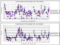
A first analysis of weather forecast in Nice - Corsica area, with respect to Corsica Ferries operational requirements was a comparison between predicted and observed data.
A primary investigation indicated that predicted wind and wave conditions were really consistent with ship observations.
But a more detailed analysis indicated that during calm wind and wave conditions, forecast were generally overestimating, while during severe conditions they were sometimes slightly underestimating.
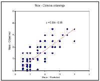
This is verified by a regression analysis, which showed also quite a large scatter between forecast and observation, as usual for such analysis.
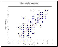
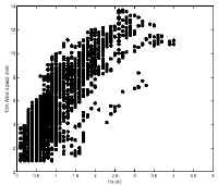
In addition, a basic analysis of wind and wave conditions observed from satellites in Nice - Corsica area indicated a generally good correlation between local wind and significant wave height.
However, this plot showed some data that did not have the same properties than the whole remaining data: the dots with wind speed between 4 and 8 m/s and significant wave height between 2.3 and 3.5m to the lower right of the main group.
It appeared that these data were observed on May 21/22, when Corsica Ferries reported some divergences between weather forecast and actual marine conditions. The particular weather condition during this period was investigated and this analysis was helpful for identification of some causes of divergences between forecast and actual weather conditions.
|
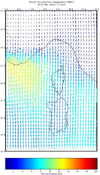
On
May 20 at 21:26, observations by ERS-2 showed a strong gradient
of wind (and of wave as well) between Sardinia and France,
westward of Corsica, with wind speed decreasing from about
13m/s near Sardinia to about 3m/s near the French coast. That
situation is typical of spatial variations of wind in the
Mediterranean sea. A similar trend was present in the ECMWF
wind field but with a smaller gradient, but a finer spatial
resolution is required for an accurate description of wind
fields. It is clear that the mesh size of ECMWF model is too
large to simulate accurately such wind gradients. |
|
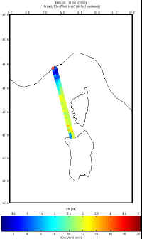
On
May 21 at 04:07, observations by Topex, eastward of Corsica,
showed strong wind gradients along the Italian coast, that
were not apparent in the ECMWF wind field (which described
strong winds westward Corsica and only a slight increase in
wind speeds eastward). This observation and the previous one
can be brought together because there were made with only
7 hours of time lag. This also tends to indicate that during
this particular period, there were possibly two pressure lows
at close locations, one in the west of Corsica and the other
on the eastern side, but that the eastern one was not well
predicted. Based on the limited available information, this
could not be fully demonstrated, but Corsica Ferries reported
that on May 21, a severe storm occurred that was not accurately
predicted. This corresponds to the period with wind speed
- wave height pairs of unusual properties that were spotted
in the figure above. Therefore, it is probable that an unusual
meteorological pattern occurred during this period, which
was not correctly predicted by weather forecast. |
|
On
May 22 at 19:03, observations by Topex, westward of Sardinia,
then in the Southwest of Corsica and in the Northeast of Corsica,
showed low wind and large waves in the West of Sardinia but
low waves to the Northeast of Corsica. This particular situation,
with low wind and quite strong wave gradient can be related
to the storm described above and to the unusual wind-wave
pairs. |
Other analyses can be found in the full report.
|
|
|
|
|
Research actions
|
| The analysis showed some limitations in the accuracy of weather forecast in this area of the Mediterranean Sea, where local conditions can influence weather and sea states, with sometimes rapid changes from mild to severe weather conditions.
This can be related to the limited amount of observations and measurements of wind and sea conditions in the area, but also to the resolution of weather forecast models, too low with respect to the rapid and local changes of weather conditions in the Mediterranean Sea. |
| The input of satellite observations is too limited today to significantly contribute to improve weather forecasts performance at the level of the regional and temporal details required for HSC operation.
This is the consequence from too scarce a satellite coverage, and of measurements limited to narrow tracks in general.
However, if satellite coverage were widely extended, and if satellite observation were transmitted to weather forecast offices in near real time, significant improvement in local weather analysis and therefore in weather forecast could be attained. |
| Also, if satellite coverage was significantly extended, and if wind and sea observations were transmitted to HSC operators in near real time, this would give them complementary information to make decisions for managing HSC crossings in critical situations.
For instance, this additional information would help in decisions whether to cancel the crossings, in addition to the information presently available. |
|
|
|
User persuasion
|
| HSC operators are demanding more reliable information on actual wind and sea conditions in their operational area, ... but there are only about half-a-dozen cases in the summer season when such additional information is actually necessary. |
| There is a clear demand from HSC operators for a kind of network that would dispatch (and possibly merge) all available information (land and ship observations, coastal and open sea measurements, weather forecast, satellite measurements) on a near real time basis. |
|
|
|
Expected improvements
|
| It would be necessary to improve by an order of magnitude the time and space coverage, which could be done if a large number of satellites were launched. |
| This improvement of the coverage is of more priority to industry users than the refinement of the sensing systems. |
|
|
Links and references
|
|
|
Providers of satellite data
|
|
|
|
The COMKISS project:
|
 Project objectives
The main objectives of the project are:
to demonstrate to major segments of the marine transport industry the benefits of integrating satellite-derived information on sea state such as wave height and direction.
to raise awareness of the usefulness of satellite data in increasing the safety and overall efficiency of shipping operations by using the EWSE (at CEO) as the principal channel for communicating progress.
The results should be of interest for enterprises such as ship certification, fast ship/coastal traffic, and transportation of unconventional loads.
Project partners
Satellite Observing Systems , Godalming, UK (David Cotton, project manager)
Mathematical Statistics, Lund University, Sweden (Georg Lindgren, project co-ordinator)
Bureau Veritas, Paris-La Defense, France (Guy Parmentier)
Dockwise, Meer, Belgium (Cees Leenaars)
IFREMER, Brest, France (Michel Olagnon)
OPTIMER, Brest, France (Raymond Nerzic),
Corsica Ferries, Bastia, France
Project period
September 1, 1998 - August 31, 2000
|
Back to top | Back
to modules list
|