 |
Case study: Fatigue and failure
|
|
|
 |
This study addresses the design rules in shipbuilding.
Conventional strength criteria for ships are based on a description of loads that is independent of actual ship service and corresponds to worst sea conditions expected over a period of 20 years.
Knowledge of actual sea conditions would allow to demonstrate the capacity of a ship designed for a specific service.
A second topic is to investigate the possible spatial structure of the wave climate, in particular the dependence structure over extended areas, in order to make possible the estimation of the fail-safe properties of ocean crossings, in particular to find the distribution of the worst wave conditions over a fixed period of time, typically 10-15 days.
|
|
 |
General description
|
The case study reported here was carried out in the COMKISS European project.
It was broken into two parts.
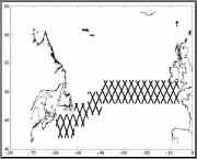
A Mediterranean and Eastern Atlantic route Trieste-Rotterdam was chosen for the design rules and a Northern Atlantic route Rotterdam-Boston for the fail-safe part.
The two routes are not only different from a meteorological point of view, but they are also monitored by the satellite passages in quite two different ways.
The Trieste-Rotterdam, in particular the Adriatic part near Trieste, is rather nearshore, and there are many missing or unreliable data.
The Atlantic data are rather reliable and stable.
The parameters for the statistical distributions in the wave characteristics are of course different and vary along the routes, with small and regular variations in the Atlantic, and larger ones in the
Mediterranean.

|
|
|
Typical applications
|
Fatigue is one of the most important criteria in the design of ships.
Estimation of the fatigue loading can be significantly improved if precise climate information, including seasonal trends, can be made available all along the route.
The fail-safe condition would correspond for instance to avoidance of the risk that a crack in a LPG carrier, undetected at the inspection before sailing off, would propagate to full ruin during a single, extremely severe, voyage of 10 to 15 days.
|
|
State of the Art - Old and new
|
 |
|
Present methodology
|
The conventional method, fatigue assessment by direct calculation, is based on the partitioning of the oceans in the areas of the Global Waves Statistics atlas, and on a combination of the corresponding Hs-Tz scatter diagrams with weights corresponding to the probability of presence of the ship in each area.
Due to the wide geographical extent of the areas, this method does not describe precisely the climate of routes, and averaging of conditions over areas where strong climate gradients exist may lead to severe over- or under-estimation of the actual fatigue damage.
Moreover, the method is at loss to provide any realistic estimation of the probability and the nature of the ``most severe'' conditions on a given route.
|
|
|
Recent improvements
|
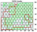
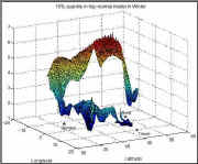
Satellite altimeter measurements of significant wave height Hs give an opportunity to refine the estimation of the distribution of sea states, both in space and in seasonality.
In the study, the Topex-Poseidon data provided by the SOS WAVSAT archives were used to this aim.
Time was separated between summer and winter months, and space in square bins of about 2 by 2 degrees.
The following procedure was then applied:
| Reconstruction of missing values in each track |
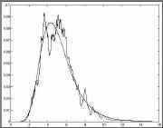
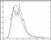
| Fit of a parametric (log-normal) distribution to the observations in each bin. |
| Validation of the processing method. |
| Parameterisation of the distributions with respect to the position on the route. |
| Units meters and m/s |
| Computation of overall damage distribution for voyages along that route. |
|
|

|
|
Analysis of the example
|
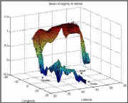
This experiment was a good demonstration that the probability density function of Hs and Tz could be modeled along a given route, and the parameters of the model estimated from satellite data.
However, for a given voyage, the sea states that are encountered are correlated in a manner that cannot be straightforwardly estimated from satellite measurements.
This is the reason for the definition of the problem described in another module.
|
Conclusions
|
 Joint probability density functions of wave height and period can be accurately estimated on a given route for a given season from satellite data. Joint probability density functions of wave height and period can be accurately estimated on a given route for a given season from satellite data.
The estimation is robust, and superior in definition to what climatological atlasses can provide.
These pdfs can be transformed to the damage increment distributions that are of primary interest to design and risk assessment.
|
|
|
 |
|
Research actions
|
| Provide a clear statement of the problem for the correlated conditions encountered in a single voyage. |
| Improve the model of the probability density function of the overall fatigue damage cumulated during one voyage along a given route. |
|
 |
|
User persuasion
|
| Fail safe conditions (and fatigue over a single voyage, for sea-fastening for instance) need to be understood in a stochastic manner.
This condition is necessary because satellite data does not directly provide sea state histories that could be used for more deterministic approaches. |
|
|
|
Expected improvements
|
| It should become possible in the future to consider the correlation of the sea-states that are encountered along a given route in a single voyage. |
| The services providers should soon be able to give directly height-period, or even damage distributions for a simple transfer model, for a given route instead of asking the user to combine local information. |
|
|
Links and references
|
|
|
The COMKISS project:
|
Project objectives
The main objectives of the project are:
to demonstrate to major segments of the marine transport industry the
benefits of integrating satellite-derived information on sea state such as
wave height and direction.
to raise awareness of the usefulness of satellite data in increasing the
safety and overall efficiency of shipping operations by using the EWSE
(at CEO) as the principal channel for communicating progress.
The results should be of interest for enterprises such as ship certification, fast
ship/coastal traffic, and transportation of unconventional loads.
Project partners
Satellite Observing Systems , Godalming, UK
(David Cotton, project manager)
Mathematical
Statistics, Lund University, Sweden (Georg
Lindgren, project
co-ordinator)
Bureau
Veritas, Paris-La Defense, France (Guy
Parmentier)
Dockwise, Meer, Belgium (Cees Leenaars)
IFREMER, Brest, France
(Michel Olagnon)
OPTIMER, Brest, France (Raymond Nerzic),
Corsica Ferries, Bastia, France
Project period
September 1, 1998 - August 31, 2000
|
Back to top | Back
to modules list
|