 |
Case study: Sea State Alarm
|
|
|
 |
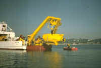
Tow-outs of large structures, deck matings, laying of submarine telecommunication cables or of pipelines have to be carried out offshore in all the oceans of the world.
The ships and barges dedicated to this type of operations have operational limits usually about 4 to 5 meters significant wave height.
Advance notice of, say, six hours, in case of worsening of the sea conditions allows to make preparation for a smooth turning down of the system, and thus a quick resuming of the operation when the weather improves again.
On the opposite, if the vessel is taken unprepared, the end of the cable or of the pipe has to dropped out in such a manner that the restart will be lengthly and costly.
Of course, decisions based on false alarms may show also very costly.
The problem is thus to increase, at low cost, the reliability of the forecast information that is made available on-board for making decisions in case of sea conditions close to the operational limits.
|
 |
 |
General description
|
The case study reported here was carried out in the COMKISS European project.
It consisted of provision of an experimental Sea State Alarm service by
Satellite Observing Systems Ltd. to cable ship Dock Express 20 of Dockwise N.V. during the lay-out of a San-Francisco -- Guam telecommunications cable in spring 1999.
The service provided, electronically and with twice daily coverage:
| a map comparing satellite measured significant wave heights with recent wave forecast (FNMOC maps), |
| e-mail warnings when wave heights in excess of specified limits were detected. |
The objectives of the experiment were to test the usefulness of the SSA service, and to collect suggestions and improvements from user feedback.
|
 |
|
Typical applications
|
In addition to the cable- and pipe-laying applications, a service such as SSA would be relevant to oceanographic campaigns, where submersibles or instruments are operated from an oceanographic vessel, to salvage operations for wrecks, or to offloading of offshore oil production facilities, for instance.
In general, any operation where a limit is set on operability with respect to sea state and where it is undesirable or impossible to sail away, can benefit from such a service, improving the reliability of the
forecasts of wave heights, wind speeds, or ship responses.
|
|
State of the Art - Old and new
|
|
|
Present methodology
|
Operations such as the example cable laying are supported by an extensive weather forecast provision: weather fax, NAVTEX, SAT-C broadcasts, and also dedicated forecasts from an international
forecast provider.
Most of these forecasts are available on a 6 hourly basis.
It should be noted that regular weather services like Navtex, weather telex via SATCOM-C, weather fax, are free of charge, and that all necessary equipment is compulsary on board.
Dedicated weather services cost a few hundred Euros per week, excluding communications costs.
A SATCOM-A, B or mini-M may be necessary, and not all vessels are equipped to receive internet e-mail
|

|
|
Recent improvements
|
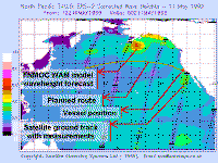
During the experiment, maps were sent as graphical files to the board:
| General waveheight contour map of FNMOC WAM model |
| Satellite measurements plotted as overlays, using the same colour scale |
| Area covering Northern Pacific Ocean |
| Planned route + last reported ship position |
| Units meters and m/s |
| File size around 44 KB, one or two updates per day |
However, the transmission used internet, and in practice, e-mails to the vessel were held in a mailbox and reached the board only when the crew decided to poll it.
In case of wave heights above the operational limit, a specific warning was sent.
|

|
|
Analysis of the example
|
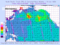
From a simple comparison, one can see that the FNMOC model seems to underestimate high wave heights (12-6-99). On the opposite, although this is of little consequences, calm sea-states are overestimated.
The storm to the NE of the ship's location on 12.6.99 was ``behind'' her, and the corresponding warning was thus not of a nature to change any decision on board.
Had it reached the board earlier, the warning of 14.6.99 would have fully demonstrated the interest of the satellite data correction to the forecast.
However, because of the time and span between satellite measurements, and of the procedure that the board had to poll its mailbox to retrieve the map, the crew were fully aware of the actual wave heights when they retrieved the satellite corrections.
This experiment was thus a good demonstration of the validity of the principles used, and a strong encouragement to palliate the practical defects in an operational
follow-up.
|
Conclusions of captain Dock Express 20 after trial:
|
 Data was considered correct, measurements close to vessel position were accurate. Data was considered correct, measurements close to vessel position were accurate.
Graphical presentation is clear, best is to cover a large area of interest No operational decisions were made on basis of SSA data.
This conclusion is based on the fact that route deviations are not possible. SSA warnings should be sent by FAX, vessel can then poll the data Data was used to confirm other weather forecasts General experience was that the wavemodel forecast was overestimating.
Therefore it was neglected. Regular available forecasts were used instead. SSA gave early warning to unpredicted adverse weather conditions Size of data ~45 KB (= transmission time) was considered reasonable,
especially when compared to the international
forecast provider's data (200 - 270 KB)
|
|
|
|
|
Research actions
|
| Provide a single consistent map by blending data into predictions. |
| Extend application from open sea to nearshore and to closed seas. |
| Append wind speed/direction and wave direction/period. |
| Subdivide wave data into sea and swell if feasible. |
| Increase satellite density, in order that warnings are not late as on 14th June. |
|
|
|
User persuasion
|
| Ship owners see no overlapping or double services. |
| Thus, presently, SSA is not a replacement for regular forecast services. |
| Other segments of the marine industry could strongly benefit from such services:
Navies, oceanographic fleets, and, if extensions can be carried out to closed seas and coastal areas, short distance shipping and pleasure yachting. |
|
|
|
Expected improvements
|
| Launch of constellations of satellites, such as projects GANDER, or PLEIADES. |
| Assimilation of ship's observations in addition to satellite measurements. |
| Better transmission schemes from land to board. |
|
|
Links and references
|
|
|
The Sea State Alarm service
|
The Sea State Alarm service is provided by Satellite Observing Systems Ltd..
|
|
|
The COMKISS project:
|
Project objectives
The main objectives of the project are:
to demonstrate to major segments of the marine transport industry the
benefits of integrating satellite-derived information on sea state such as
wave height and direction.
to raise awareness of the usefulness of satellite data in increasing the
safety and overall efficiency of shipping operations by using the EWSE
(at CEO) as the principal channel for communicating progress.
The results should be of interest for enterprises such as ship certification, fast
ship/coastal traffic, and transportation of unconventional loads.
Project partners
Satellite Observing Systems , Godalming, UK
(David Cotton, project manager)
Mathematical
Statistics, Lund University, Sweden (Georg
Lindgren, project
co-ordinator)
Bureau
Veritas, Paris-La Defense, France (Guy
Parmentier)
Dockwise, Meer, Belgium (Cees Leenaars)
IFREMER, Brest, France
(Michel Olagnon)
OPTIMER, Brest, France (Raymond Nerzic),
Corsica Ferries, Bastia, France
Project period
September 1, 1998 - August 31, 2000
|
Back to top | Back
to modules list
|